
A very popular and challenging walk to Scafell Pike going down by Sprinkling Tarn.
Une randonnée très touristique jusqu’au sommet de Scafell Pike et descendant par Sprinkling Tarn.
Scafell Pike and Sprinkling Tarn walk information:
- Distance: 13 km
- Duration: 6h
- Ascent: 950m
- Level: Hard
- Car park: Wasdale National Trust car park, Seascale CA20 1EX, Fees apply (around £6/day if not National Trust member)
- What3words: Greet.Manly.Slept
- Toilets at the car park
- Dog friendly: Yes but only for experienced dog as this walk can be strenuous for them.

At the end of the first lockdown, in May-June 2020, we had a lot of sunny days so we decided to do Scafell Pike. Scafell Pike is the highest mountain in England at an elevation of 978 meters above sea level. I was looking for a circular walk and not just go up and down Scafell Pike, so after some searches online I found this one that looked nice.
A la fin du premier confinement, en mai-juin 2020, nous avons eu pas mal de beau jours bien ensoleillés, donc nous décidâmes d’aller faire Scafell Pike. Scafell Pike est la plus haute montagne d’Angleterre avec son sommet à 978m au dessus du niveau de la mer. Je ne voulais pas juste faire l’aller-retour en haut de Scafell Pike donc après quelques recherches sur internet je trouvais cette randonnée circulaire qui avait l’air bien.

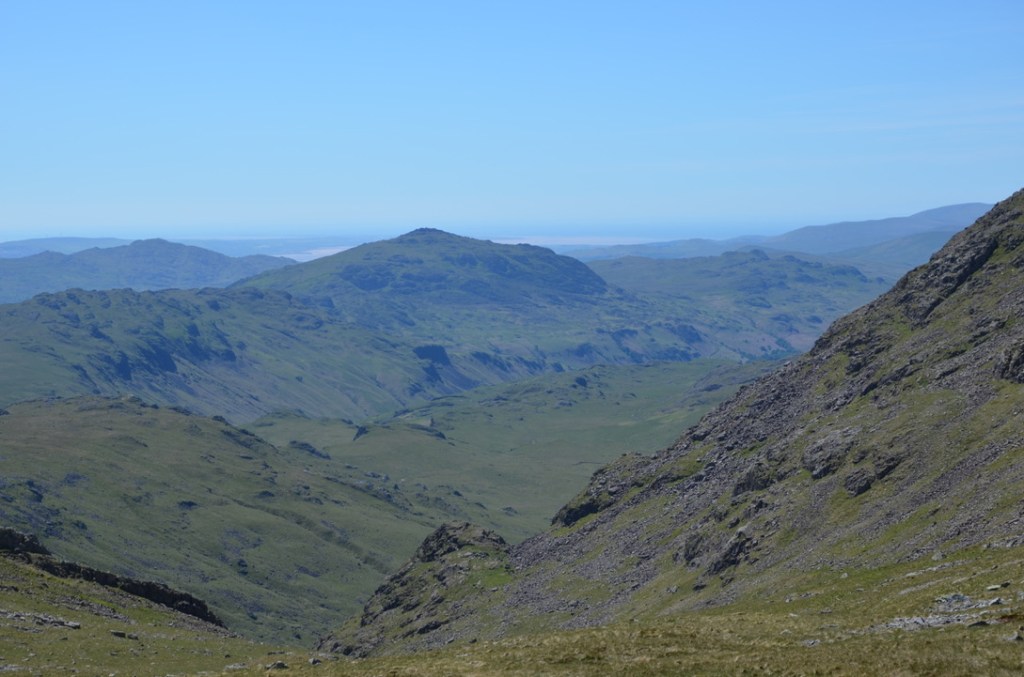
We started the walk early (around 7 am) to have plenty of time to do it and enjoy the day out. From the car park, we followed the little river Lingmell Gill towards Brown Tongue. The path that follow the river is very nice and easy and offers some nice views over Wastwater lake. Once at Brown Tongue, we continued on the main path until Hollow Stones and then the summit of Scafell Pike. The last part to the summit is very rocky and can be slippery even on a dry sunny day so I wouldn’t want to do it under the rain.
Nous avons commencé la randonnée assez tôt le matin (vers 7h) pour avoir assez de temps et aussi bien profiter de cette belle journée en montagne. Depuis le parking, nous avons suivi la petite rivière Lingmell Gill en direction de Brown Tongue. Le sentier qui suit la rivière est très agréable et facile et offre de belles vues sur le lac de Wastwater. Une fois à Brown Tongue, nous avons suivi le sentier principal en direction de Hollow Stones et puis du sommet de Scafell Pike. La dernière section pour arriver en haut du sommet est assez rocheuse et glissante même par beau temps donc je ne voudrais pas la faire sous la pluie.
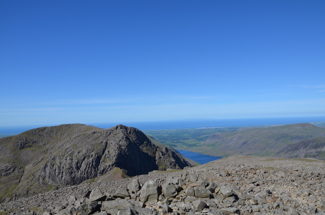
The weather was amazing that day, we had nearly no wind at the top of the summit, which allowed us to stay a long time to contemplate the gorgeous views from Scafell Pike. We could clearly see the Isle of Man and a wide area of the Lake District National Park.
Le temps était splendide ce jour là, et il y avait très peu de vent arrivé au sommet ce qui nous a permis de bien profiter de la vue depuis le haut de Scafell Pike. Nous pouvions voir l’ile de Man et une large partie du parc national du Lake District.
We followed our hike by going down towards Broad Crag, Esk House in order to reach Sprinkling tarn. I have to admit that I hated the way down from Scafell Pike to Broad Crag. It was too steep, full of loose rocks and then very rough terrain. All the things that I hate on a walk. After some efforts we managed to reach Sprinkling tarn where we stopped for a well deserved lunch and a little dip in the tarn.
Nous avons continué cette randonnée en descendant par Broad Crag et Esk House pour arriver au niveau du petit lac de Sprinkling. Je dois admettre que je n’ai pas du tout aimé le sentier qui descend de Scafell Pike vers Broad Crag. Le sentier est très pentue, pleins de pierre et le terrain est juste très accidenté. Tout ce que je déteste dans une randonnée. Après quelques efforts, nous arrivâmes au niveau de Sprinkling tarn, où nous nous arrêtâmes pour manger et une petite baignade.

We continued in the direction of Sty Head, we could see a lot of people having their lunch and enjoying the sun on the shore of Styhead tarn. At the mountain rescue shelter box, we took left by Bursting Knott path, then followed Moses Trod path up to the hamlet and back to the car park following the main path.
Nous sommes partis ensuite en direction de Sty Head, d’où nous pouvions voir pas mal de gens manger et profiter du soleil en bordure du lac de Styled tarn. Au niveau de l’abris de secours en montagne, nous avons pris à gauche en direction de Bursting Knott path, puis du sentier de Moses Trod avant de rejoindre le parking en suivant la route principale.
Overall, it was a great day in the fells. The hike is challenging but the views are really worth it. As it was at the end of the first lockdown it wasn’t too busy that day so we could really enjoy the walk to Scafell Pike summit.
Pour résumer, ce fut une belle journée en montagne. La randonnée est assez dure mais le paysage et les vues sont vraiment magnifiques et valent l’effort. Aussi, vu que c’était vers la fin du confinement il n’y avait pas beaucoup de monde ce qui nous a permis de vraiment profiter de cette randonnée.
Have you been up to Scafell Pike Summit?
Avez vous déja fait une randonnée jusqu’ en haut de Scafell Pike?


Find all our dog-friendly walks in this page. To discover the United Kingdom it is here.

Nothing better than a walk up to the highest point in England, yes it is a very tough walk and rocky but lots of the highest points are. I remember the walk from Scafell Pike to Great End as like a moonscape, almost barren. But I remember loving the views from the dips in between these fells steeply down to Eskdale or Wasdale
LikeLiked by 1 person
We saw Great End summit from this walk. It did look challenging to go to the top. As you said the reward is the views.
LikeLiked by 1 person
The views off the front of Great End down to Seathwaite and Borrowdale are stunning, its another rocky summit though and after the boulder field from Scafell Pike I can understand why you didn’t head up there. Great walk back down though via the two tarns
LikeLiked by 1 person
I will keep it in mind for another walk during summer. Thanks for the recommendation 🙂.
LikeLiked by 1 person
What a great day to be on top of England.
LikeLiked by 1 person
Yes we couldn’t have hope for a better weather.
LikeLiked by 1 person
Many years ago (early 1980s) we climbed either Sca Fell Pike or Sca Fell, I can’t be sure now. I think it was probably Sca Fell though. Whichever, it was March and it snowed while we were up there so it is not a pleasant memory!
LikeLiked by 1 person
Oh no what a shame that you didn’t enjoy it. Apparently Sca fell is very nice but maybe better to do them during summer day.
LikeLiked by 1 person
Looks like such a beautiful hike, with views that are worth the effort! I want to get out and hike more, it’s such a relaxing activity!
LikeLiked by 1 person
It is a bit hard but really worth it. Living next to the national park helps finding the motivation to go hiking ans having a dog as well 😂. I am sure you have lovely hikes around your doorstep.
LikeLike