One of the most remote Wainwright summit, Black Combe is a great challenging walk with stunning view on the Irish sea. Dog friendly.
Un des sommets Wainwright le plus isolés, Black Combe est une randonnée assez difficile avec de magnifiques vues sur la mer d’Irlande. Accessible aux chiens.
Black Combe walk information:
- Distance: 14 km
- Duration: 4h
- Ascent: 780m
- Level: Medium
- Car park: Honesty box by St Mary’s Church, Whicham, Millom LA18 5LS
- What3words: Artichoke.shocks.huddled (start of the walk)
- Dog Friendly: Yes, some fields with sheeps, a short section of the walk is done on the verge of the A595.

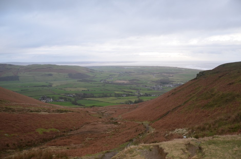
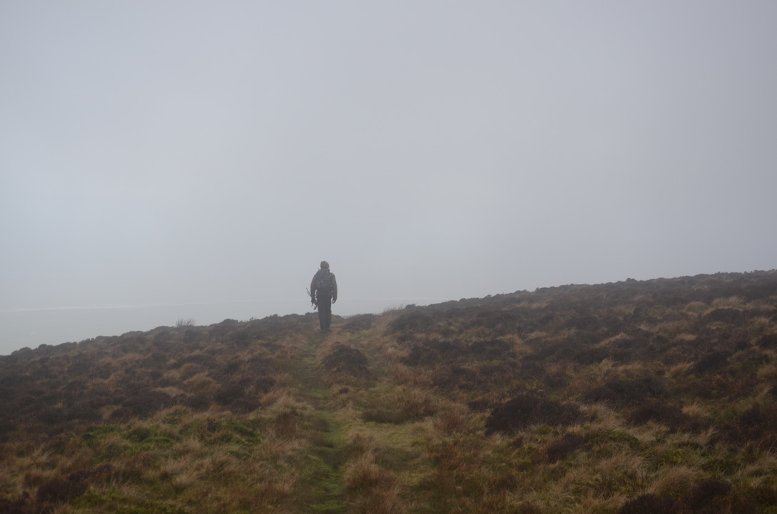
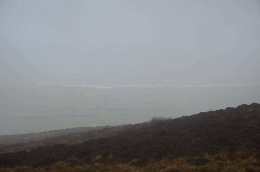
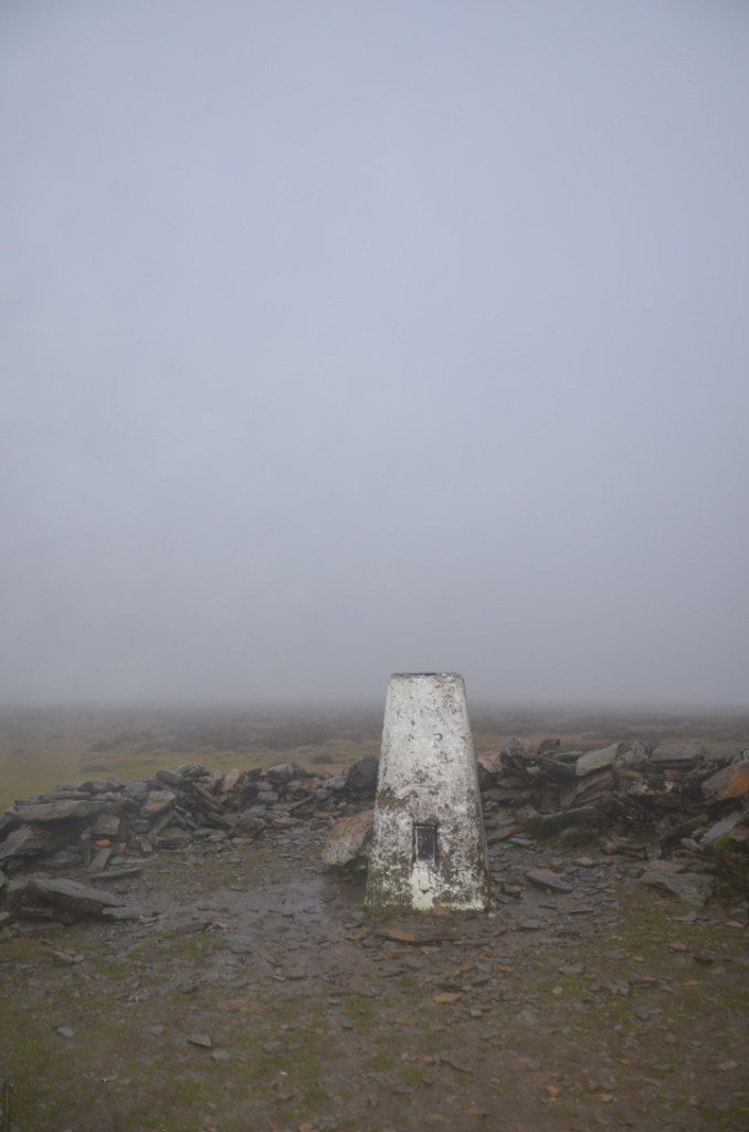
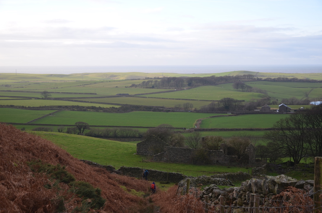
A fortnight ago, we decided to do Black Combe. This peak, located southwest of the Lake District National Park, is quite isolated as it is closer to the Irish Sea than other peaks in the park. On a clear day you can see the south coast of Scotland, the Isle of Man and even the summit of Snowdon in Wales. Unfortunately, the day we went there we couldn’t see more than 20 meters in front of us. However, when we started the hike the sky was quite clear but as we went up the fog thickened and surrounded us. So it was, without seeing anything that we arrived at the top of Black Combe. As I don’t like to walk in such conditions at all I just wanted to turn back, but our friends absolutely wanted to finish the 14 km loop that we had planned to do that day. It was thus in this freezing wind and this thick mist that we continued for a while. Then finally after descending for a moment, we emerged from the fog and were able to observe a beautiful view of this Irish sea. The end of the hike was done under a clear sky. So, I have a rather mixed feeling on this hike because the weather conditions spoiled this morning a little bit. I think I would go back this summer on a clear day to really appreciate its full extent. Otherwise the path is clearly visible, wide and easy to access. Only the climb up to Black Combe can be hard but once at the top, the path only descends or is practically flat.
Il y a quinze jours de ça, nous avons décidé d’aller faire Black Combe. Ce sommet, situé au sud-ouest du parc national de Lake District, est assez isolé car il se trouve plus près de la mer d’Irlande que d’autres sommets du parc. Par temps clair, il possible de voir la côte sud de l’Ecosse, l’île de Man et même le sommet de Snowdon au Pays de Galles. Malheureusement, le jour où nous y sommes allés nous n’avons pas pu voir plus de 20 mètres devant nous. Pourtant quand nous avons commencé la randonnée le ciel était assez dégagé mais au fur et à mesure que nous montions le brouillard s’épaississait et nous entourait. C’est ainsi, sans voir quand chose que nous arrivâmes en haut de Black Combe. Vu que je n’aime pas du tout marcher dans de telles conditions j’avais juste envie de rebrousser chemin mais nos amis avaient absolument envie de finir la boucle de 14 km que nous avions planifié de faire ce jour-là. C’est alors dans ce vent glacial et cette épaisse brume que nous avons continué pendant un moment. Puis enfin à force de descendre, nous sommes sortis du brouillard et avons pu observer une belle vue sur cette mer d’Irlande. La fin de la randonnée se fit sous un ciel dégagé. J’ai donc un sentiment assez mitigé sur cette randonnée car les conditions météorologiques ont un peu gâché cette matinée. Je pense que j’y retournerais cet été par temps dégagé pour vraiment apprécier toute son ampleur. Sinon le chemin est bien visible, large et facile d’accès. Seul la monté jusqu’à Black Combe peut être dure mais une fois en haut, le chemin ne fait que descendre ou est pratiquement plat.
Here are the key steps to do this hike:
Voici les étapes clés pour faire cette randonnée:
-From the parking, take the small path between the houses which goes towards a tarmac road. Take a left on this road towards the farms. Continue on the path, pass the farms, then turn right towards the wide path which goes up towards Black Combe.
-Depuis le parking, prendre le petit chemin entre les maisons qui va vers une route goudronnée. Prendre à gauche sur cette route en direction des fermes. Continuer sur le sentier, passer les fermes, puis prendre à droite vers le large sentier qui monte en direction de Black Combe.
-Continue on this path straight up to the summit. At the top, take the path slightly to the left. Continue straight on until you see a path junction (be careful here as it is not very visible) and take the one on the left. Descend on this trail for a long time before arriving in front of a stone wall.
-Continuer sur ce sentier tout droit jusqu’au sommet. En haut, prendre le sentier légèrement sur la gauche. Continuer tout droit jusqu’à voir un embranchement de sentiers (faire attention ici car ce n’est pas très visible) et prendre celui de gauche. Descendre sur ce sentier pendant un long moment avant d’arriver presque sur du plat devant un mur en pierre et grillage.
-At the wall, turn left and continue straight on this path which runs along the wall. Continue straight ahead until you reach a hamlet which you need to cross by following the main road. Continue on this road until arriving on the A595.
-Au niveau du mur, prendre à gauche et continuer tout droit sur ce sentier qui longe le mur. Continuer toujours tout droit jusqu’à arriver vers à un hameau qu’il faut traverser toujours en suivant la route principale. Continuer sur cette route jusqu’à arriver sur la A595.
-Take left on the A595 and continue for around 500m before seeing a path that goes up on the left indicating Black Combe. Take this path and continue straight until you find the path from the begins that goes towards the farms. Then continue straight towards the parking.
-Prendre à gauche sur la A595 et continuer pendant 500m environ avant de voir un sentier qui monte sur la gauche indiquant Black Combe. Prendre ce sentier et continuer tout droit jusqu’à retrouver le sentier de début qui arrive vers les fermes. Puis continuer tout droit vers le parking.
Have you ever done Black Combe?
Avez-vous déjà fait Black Combe?


Find all our dog-friendly walks in Cumbria in this page. To see our adventures in the United Kingdom it is here.

You don’t see many Lake district walks that take in Black Combe as most head for the Wainwrights and the more popular spots in Lakeland. Its an outlying Wainwright fell and one which is worth climbing for the views straight down the the sea on that side of the fell. Shame you didn’t get a view from the top as the vista to the Coniston range from there is very good
LikeLiked by 1 person
Yes it is a shame that people always do the same list of the summit all the time. I am sure I will have the opportunity to go back with a nicer weather to admire the view.
LikeLiked by 1 person
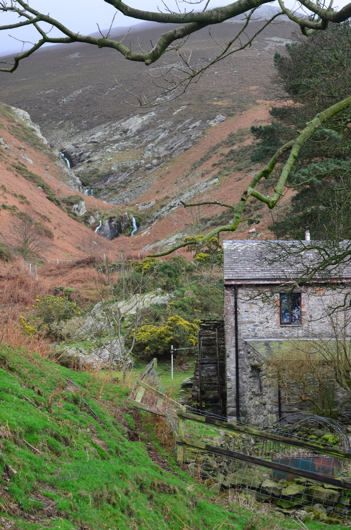
Most of my hiking in Scotland involved slogging up into the cloud and then back down again, so don’t feel too bad about it. I love the photo of the stream and the old water mill. That right there is worth the journey.
LikeLiked by 1 person
Yes I agree with you this old mill was very nice. I was very lucky because very time I went hiking in Scotland I had a nice weather.
LikeLiked by 1 person
I’m not keen on walking in poor conditions, but sometimes the skies clear- especially in mountain areas- when you don’t expect it. My walk tomorrow features such a day, out in the salt marshes. 🙂 🙂
LikeLiked by 1 person