Challenging circular walk passing by two Wainwright summits (Grasmoor and Whiteless Pike) and following Liza beck. Dog friendly.
Une randonnée assez difficile passant par les deux sommets de Grasmoor et Whiteless Pike et suivant la rivière de Liza Beck. Accessible aux chiens.
Grasmoor and Whiteless Pike walk information:
- Distance: 13km
- Duration: around 5h with breaks
- Ascent: 697m
- Level: Medium to Hard
- Car park: Just after Lanthwaite, CA13 9UY on the side of the road, free
- What3words: Certainty.paddocks.audit (car park, start of the walk)
- Dog friendly: Yes, some scrambling part and narrow path to follow along edge of the river.

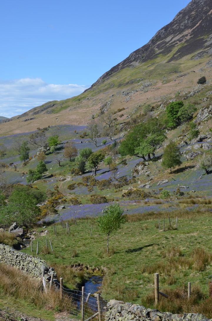
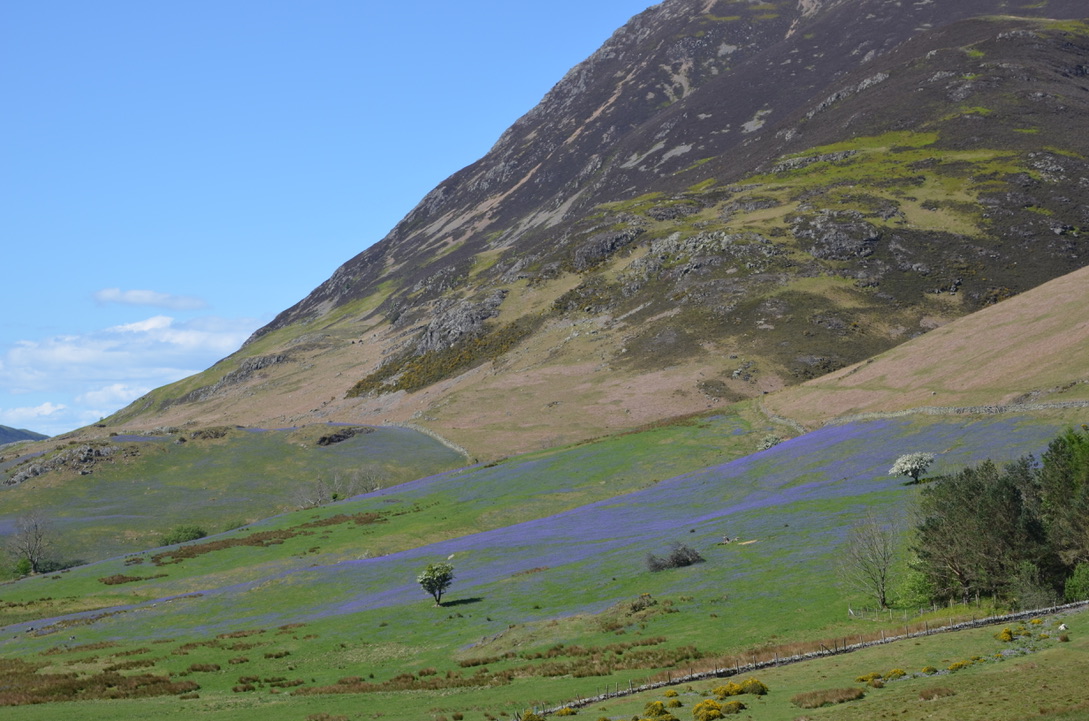
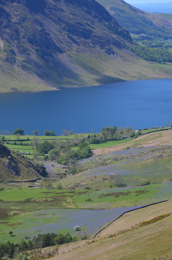
As every year, I look forward to May because it is the month of the Bluebells. Last year we went to see them in Rannerdale and we did a fairly simple hike to the top of Rannerdale Knott. This year I decided to do Grasmoor and Whiteless Pikes before going down to see the bluebells in Rannerdale.
Comme chaque année, j’attends le mois de mai avec impatience car c’est le mois des « Bluebells ». L’année dernière nous étions allés les voir à Rannerdale et nous avions fait une petite randonnée assez simple jusqu’en haut de Rannerdale Knott. Cette année j’ai décidé de faire Grasmoor and Whiteless Pikes avant de redescendre voir les bluebells à Rannerdale.
Find our walk to Rannerdale Knott here.

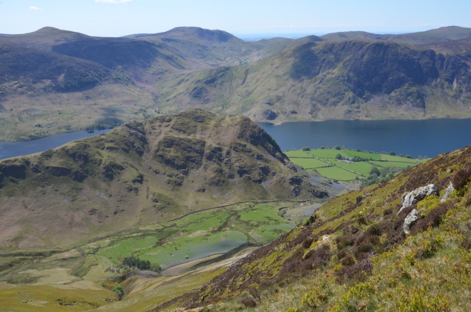
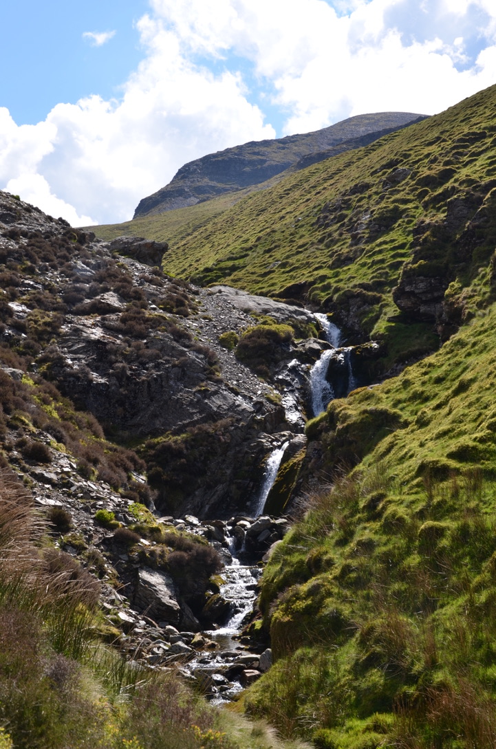
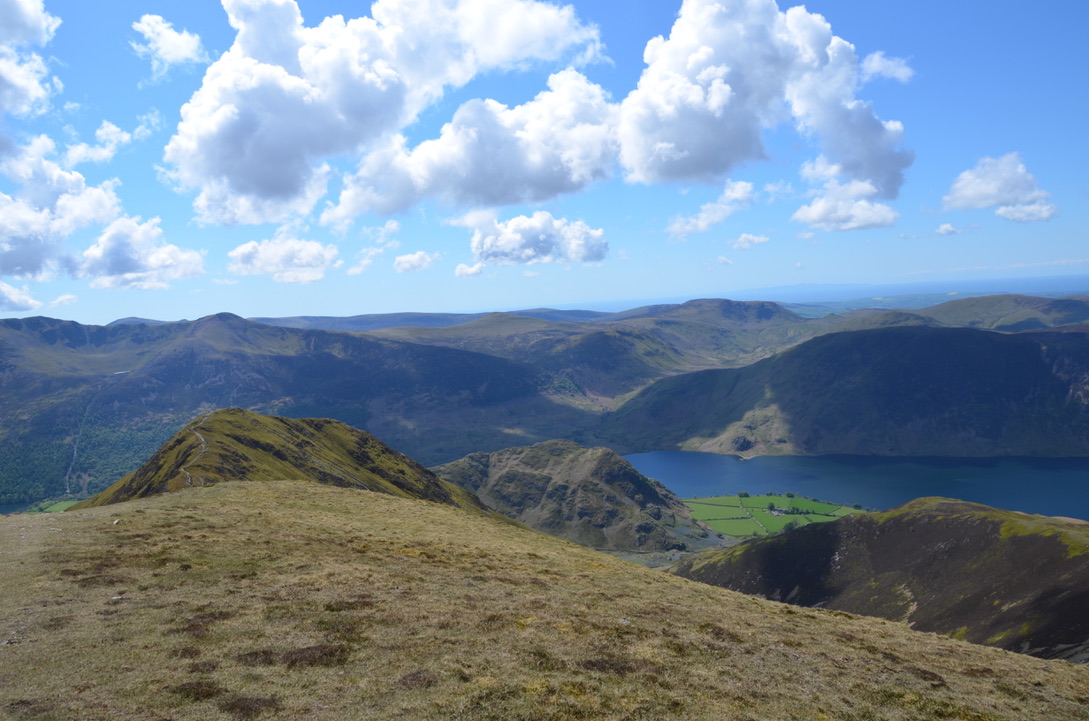
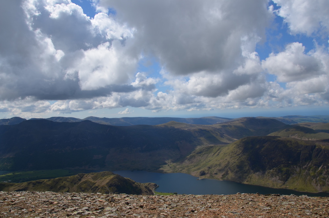
This hike is moderately hard and the view at the top of Grasmoor Pike and Whiteless Pike is absolutely beautiful. The climb along the Liza Beck stream is pleasant and with a gentle slope. Once on the plateau, the trail becomes wider, flat and more popular. Then comes the climb up to Grasmoor Peak. It is this climb that is the hardest because it is short but intense. Once at the top, it is possible to see the Scottish coast on a clear day. The end of the hike through the bluebells field is absolutely fantastic especially for photographers.
Cette randonnée est moyennement dure et la vue en haut de Grasmoor Pike et Whiteless Pike est absolument magnifique. La montée le long du cours d’eau Liza Beck est agréable et avec une pente douce. Une fois sur le plateau, le sentier devient plus large, plat et plus populaire. Puis vient la montée jusqu’au pic de Grasmoor. C’est cette montée qui est la plus dure car elle est courte mais intense. Une fois en haut, il est possible par temps dégagé de voir les côtes Ecossaises. La fin de la randonnée à travers le champ de bluebells est absolument fantastique surtout pour les amateurs de photos.
Here are the essential steps to do this hike:
Voici les étapes essentielles pour faire cette randonnée:
- From the car park, cross the road and go towards Brackenthwaite fell. Cross Liza Beck stream and take the trail that follows the stream and that goes to the middle of the valley. Continue straight until you reach the top of the stream and join an intersection of paths.
- At the intersection turn right and follow the path until you reach another intersection of path. Take the one on the right that goes up Grasmoor. Once up, go down the same path, then at the plateau turn right towards Thirdgill Head Man. Continue straight on towards Whiteless Pike and take the path down to Buttermere.
- Leave the path that goes to Buttermere to take the path on the right that goes to High Rannerdale. Continue straight to the road. Then follow the road to find the parking.
- Depuis le parking, traverser la route et prendre en direction de Brackenthwaite fell. Traverser le cours d’eau Liza Beck et prendre le sentier qui suit le cours d’eau et qui va vers le milieu de la vallée. Continuer tout droit jusqu’à arriver en haut de la rivière et rejoindre une intersection de chemins.
- Au niveau de l’intersection de chemins prendre à droite et suivre le chemin jusqu’à arriver à une autre intersection de sentier. Prendre celui de droite qui va en haut de Grasmoor. Une fois en haut redescendre par le même sentier, puis au niveau du plateau prendre à droite en direction de Thirdgill Head Man. Continuer tout droit en direction de Whiteless Pike puis prendre le sentier qui redescend vers Buttermere.
- Laisser le sentier qui va vers Buttermere pour prendre le sentier de droite qui part vers High Rannerdale. Continuer tout droit jusqu’à la route. Puis suivre la route nationale pour retrouver le parking.
Do you know this hike?
Connaissez-vous cette randonnée?


Find all our dog-friendly walk in the Lake District National Park in the page. To discover the United Kingdom it is here.

Tes photos sont magnifiques! Je n’ai jamais vu un champ de bluebells comme ça, mais les bluebells à Bodlondeb Woods près de Conwy (au nord du Pays de Galles, une région que je connais bien) sont assez jolis.
LikeLiked by 1 person
Merci pour ton commentaire. Je ne connais pas du tout Conwy.
LikeLiked by 1 person
Jolie rando, avec un joli dénivelé 😉 Je suis une grande fan des jacinthes des bois moi aussi… Et comme elles sentent bon…
LikeLiked by 1 person
Merci beaucoup,
LikeLike